America Stands Tall
New York City
Canyon of Heroes,
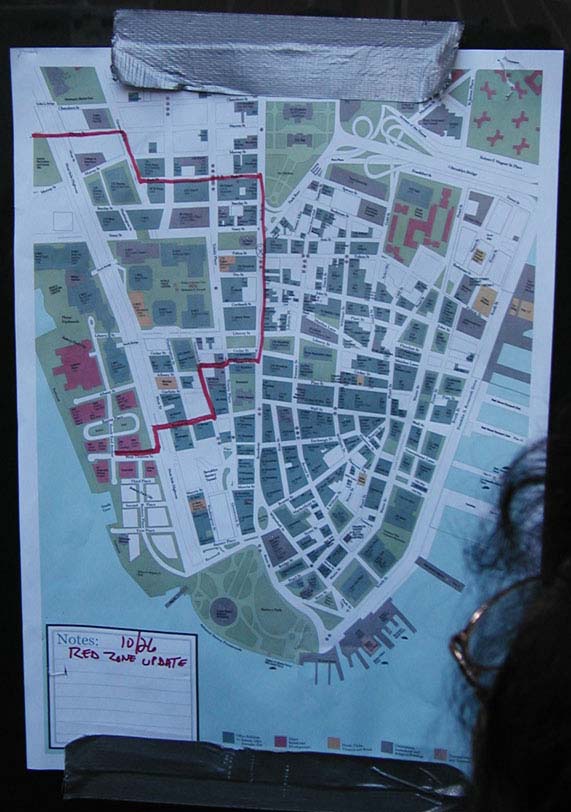
Red Zone around Ground Zero
October 29, 2001
Photos by Matthew A Perosi
This map shows the area around Ground Zero
that is off limits to everyone except
those directly involved with the recovery and cleanup effort.
The "Red Zone" has decreased
several times. On September 11 the red zone
was declared to be everything south of 14th Street in Manhattan. That
was many blocks north of the World Trade Center. You can find my write-up
about
14th Street and Union Square in the Union Square Photo Galleries.
Within a few days after the attack the
red zone was pulled south
to Canal Street. When I went to NYC on September 18, 2001 the Red
Zone was everything south of Canal Street. You can see those photos
in the Canal Street Photo Galleries.
When I returned on October 29, 2001 the
newest Red Zone map was posted
on many buildings around the area. If you look close on this map you
will see an
X in a circle. That's where this map was posted.
To the left of the X, actually inside the
Red Zone, you can see what looks like a small
green park with an oval shaped building. That building is St. Paul's
Episcopal Church.
I have a Photo Gallery for St. Paul's too, don't miss it.